Karis historical sights
Read more about the history of Karis and the historical sights you can find in the area by clicking the arrows!
Prehistory
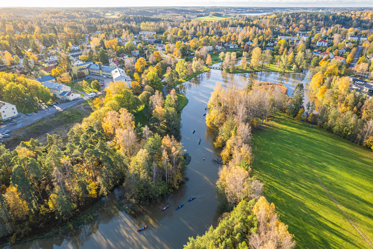
Karis (Karjaa in Finnish) boasts a long and impressive history. The first settlers came to the region during the Stone Age, approximately 10,000 years ago. During the Ice Age, around 2,500 to 1,000 years ago, Karis was one of the most heavily populated regions in Finland. Remnants of this time can be found, for example, at the Brobacka archaeological site. The area surrounding Karis pro- vides an excellent setting for the study of prehistory. The numerous historical sites found in Karis’ rural districts can be enjoyed by bicycle.
Among the medieval relics found in Karis are the ruins of the mysterious Junkarsborg Castle on the Svartå River and Grabbacka Castle just a few kilometres south of the city centre. Located in close proximity to Karis, the ruins of Raseborg Castle should definitely not be missed. During the Middle Ages, Karis was an extensive parish, which, due to the presence of Raseborg Castle, became the seat of secular power in Uusimaa. The King’s Road, which passes through Western Uusimaa and Karis, was a vital artery during the Middle Ages. Karis has always been a key nexus throughout the ages.
Ancient settlers put down their roots at the mouth of one of the country’s most important wa- terways, today known as the Svartå River. They provided for themselves primarily by fishing and hunting. The waterway was not only important to the settlers living along its banks. The Swed- ish Crown saw early on how important it would be to maintain control of this channel. This is evidenced by the three castles erected in Karis during the Middle Ages. The castle tower depicted on the Karis coat-of-arms symbolises the three medieval castles of Raseborg, Grabbacka and Junkarsborg.
Historical timeline
- 8000 BCE oldest habitation
- 500 BCE – 900 CE one of Finland’s four central settlement areas during the Iron Age
- 1326 Karis parish named for the first time
- 1470 St. Catherine’s Church consecrated
- 1560 Gustav Vasa founds Svartå Bruk ironworks
- 1870 Karis municipality founded
- 1873 Hanko–Hyvinkää railroad opens for service
- 1901 Finnish Coastal Railway between Turku and Helsinki completed
- 1930 Karis becomes a township
- 1977 Karis becomes a city
- 2009 Ekenäs, Karis and Pohja merge. The new city is named Raseborg
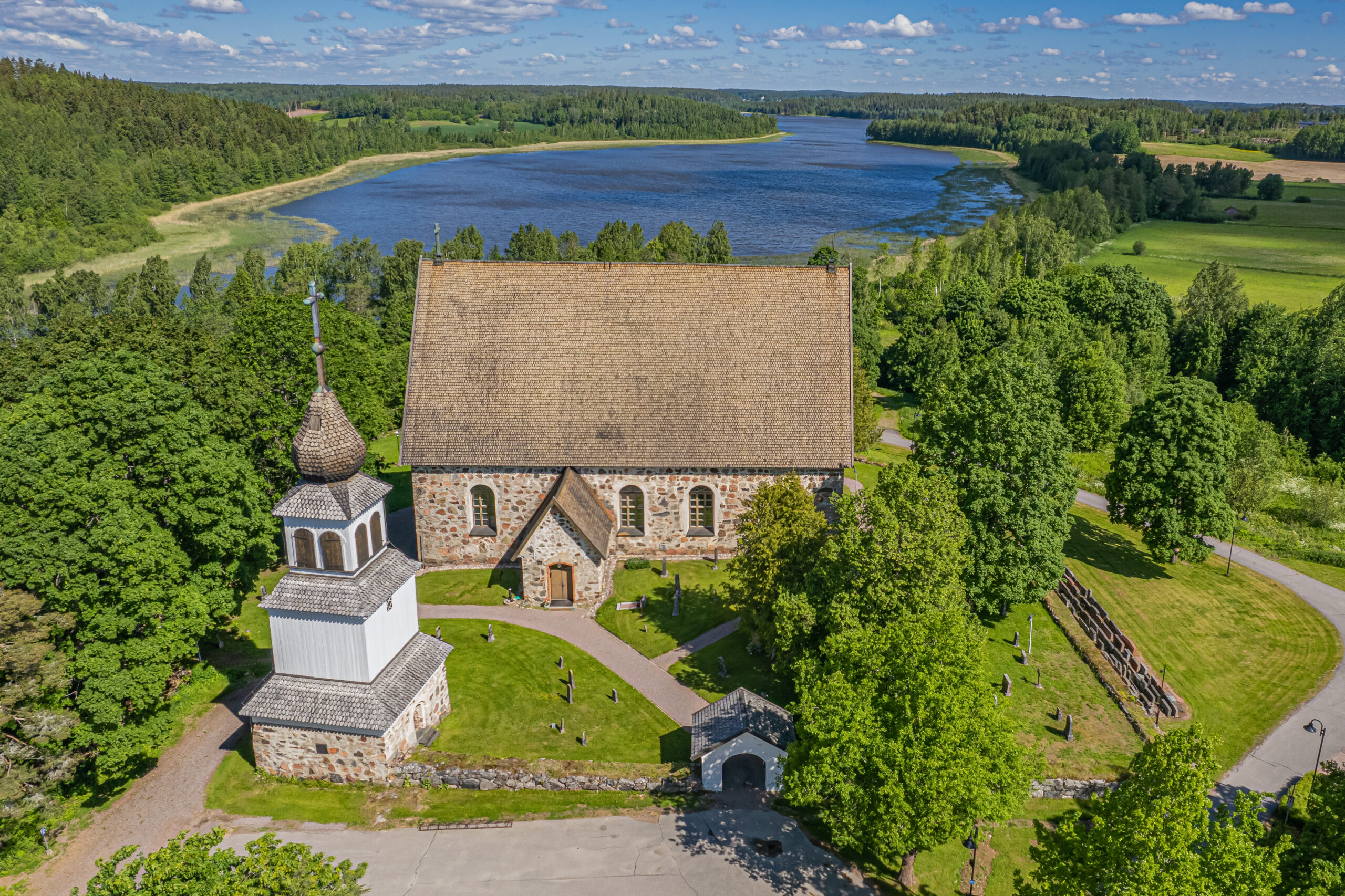
St. Catherine’s Church
The waterway running along the Svartå River to the Häme region required a defence infrastructure and the local populace needed protection. Defensive fortifications were built for this purpose. During the Middle Ages (approx. 1200–1300 CE), Junkarsborg, which is north of Karis on Lake Päsarträsket, was a population centre. In 1239 the area was the launching point for a “crusade” up the Svartå River to Hämeenlinna. In 1352 Karis became the seat of power in Western Uusimaa. In 1373 a major churchwide assembly was convened in Karis. A large portion of the Uusimaa clergy attended the assembly.
Karis’ medieval church is located a couple kilometres from the city centre, on the shore of Lake Kyrksjön. Legend has it that the church, which was consecrated in 1470, was built by Catherine of Raseborg in the absence of skilled men. Indeed, it may be so that the church received its name, St Catherine’s Church, from this intrepid woman, whose own tombstone was erected in the churchyard in 1414. The vault and wall paintings, which had been painted over, were revealed during the church’s renovation in 1936–37. The stained glass choir window was made in 1948 by Gunnar Forsström, who was born in Svartå in 1894. The church was renovated again in 2007.
The Grabbe Canal
The Grabbe Canal is a medieval remnant from the 1200s to 1300s. It served as a transport route cut through the lowest point of the Lohja Ridge where the city centre of Karis stands today. The canal can best be seen alongside Kroggårdsvägen between two industrial lots south of the railway line. The Grabbe Canal was originally at least 500 m long, stretching from the banks of Svartå River out to Kilamossen, which was till the northernmost shoreline of Lake Läppträsket at the end of the Iron Age.